Airstrip Info
| Frequency | 122.90 |
|---|---|
| Elevation | 8250 ft |
| Lat/Long |
39.6952, -110.2503 39° 41.712' , -110° 15.018' |
| Runway 3/21 |
3500 ft
Dirt |
| Ownership | SITLA (NE) / BLM (SW) |
Weather
See more at the National Weather Center
Information updated January 10, 2023 @ 5:06pm
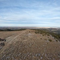
Airstrip is visible. Road down the middle. State lands.
Overflew the strip… at least I think we did. Not much there. If what we were seeing was truly the airstrip, it appears to not have been used in a long time. Rwy 03 appears to have had a grader on it at some point in the distant past. Any grading quickly fades into a two track dirt road as you approach Rwy 21. Not sure where the end of Rwy 21 is, but there are several pinion/juniper trees just off the sides of the two track that likely wouldn’t bode well to using the 21 end of the strip. Hate to list a runway as unsafe/should not be used as it’s very subjective and someone with better equipment/skill level may find it doable, but for me, that condition is appropriate.
We haven't written a history for this airstrip yet. If you would like to provide us with some information about this strip, please contact us today!
