Airstrip Info
| Frequency | 122.90 |
|---|---|
| Elevation | 4670 ft |
| Lat/Long |
38.675, -108.9883 38° 40.5' , -108° 59.2998' |
| Runway 18/36 |
2358 ft
x 75 ft
Dirt Rwy 18 Uphill 3.4% |
| Ownership | BLM |
Weather
See more at the National Weather Center
Information updated May 31, 2024 @ 9:53am
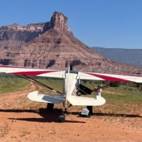
Description: This is a public BLM airstrip with service to the adjacent resort at Gateway. Use this to stay at their resort! Uphill to the south and tucked into the junction of a canyon, this strip, while long and in good condition, should be still given caution.
Runway: The centerline of the runway is mostly small gravel and hard pack dirt. Towards the edges larger rocks and clumps of grass may cause a problem for smaller tire aircraft. Sloping considerably uphill to the south the runway ends nearly at the canyon wall. With a tailwind on final a late go around may not be possible. Downhill landings into the wind are possible but will require a modified final to avoid higher terrain just off the end of the runway.
There is an active helicopter tour operation at the Gateway Canyon Resort (next to the airstrip), so announce your intentions when you get in the area. There is no windsock on the airstrip, but there are flags and a windsock at the resort. The runway is pretty smooth/firm, but with clump grass. There is a jeep trail on the runway that runs slightly off the centerline for the entire length. The resort is 5-star and has a world class car museum, restaurant and an adventure center where you can rent atv, jeeps, etc. The Delores airstrip is located on the mesa above Hubbard/Gateway. Beautiful place to fly!
We haven't written a history for this airstrip yet. If you would like to provide us with some information about this strip, please contact us today!

