Airstrip Info
| Frequency | 122.90 |
|---|---|
| Elevation | 4815 ft |
| Lat/Long |
38.035, -110.5868 38° 2.1' , -110° 35.208' |
| Runway 13/31 |
2500 ft
Dirt, asphalt |
| Ownership | BLM |
Weather
See more at the National Weather Center
Information updated January 18, 2025 @ 11:56am
The Road Junction 95-276 airstrip is a road that was recently recognized by the BLM as OHV-Open. Users of this airstrip should exercise caution for potential use by other OHVs and other road vehicles.
Cracked asphalt surface per the report.
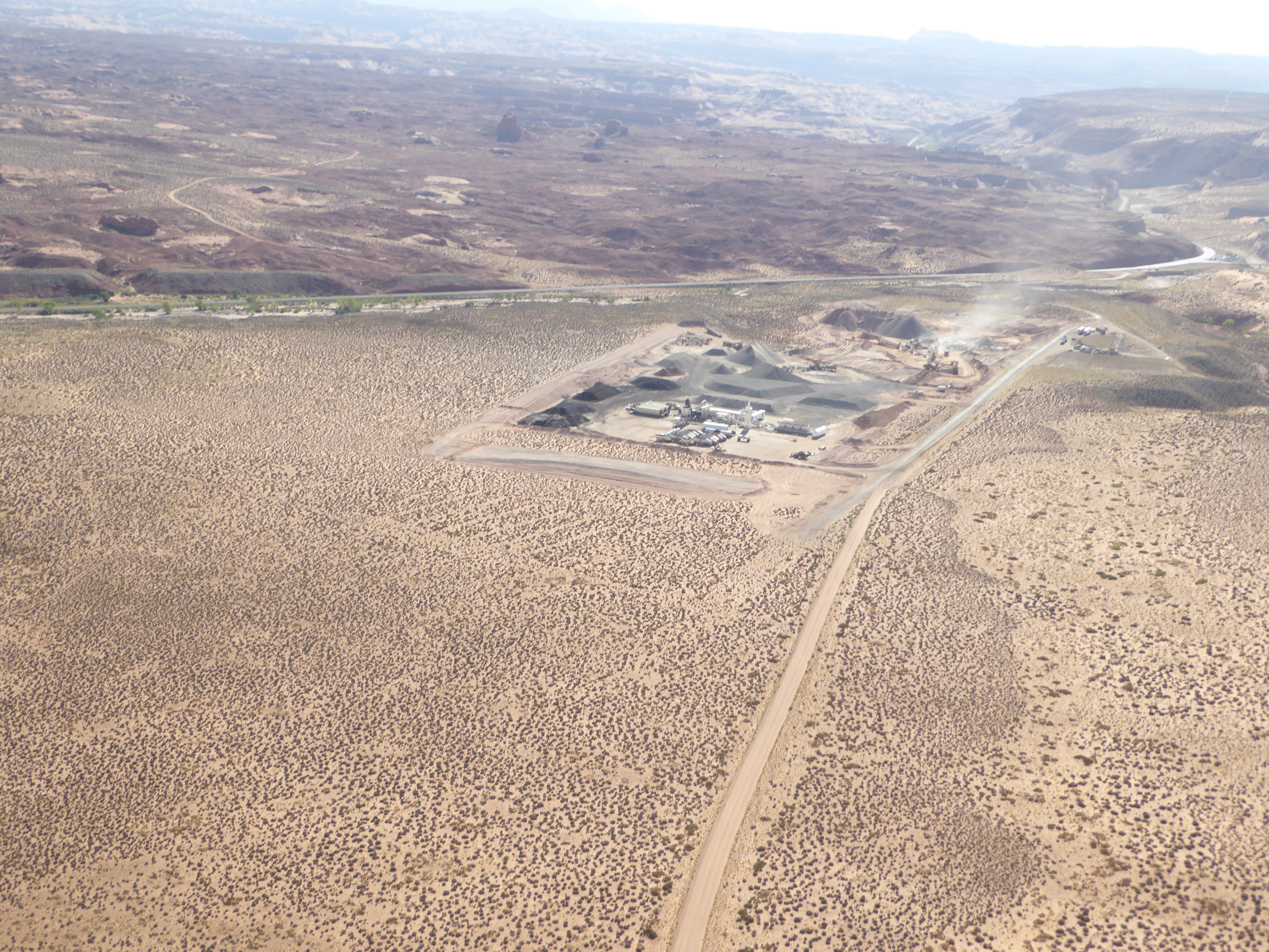
CLOSED. Permanent or temporary I don't know. The area immediately to the east of the runway is now being used for what appears to be construction material storage. see photo. The runway is now their road access. There is construction going on at the junction of roads 95 & 276 itself...whether this is what the storage is all about, I don't know.
I call this strip "Sandthrax", due to its proximity to the Poison Springs Canyoneering area and the Campground of the same name, all of which I know very well by road (and rope). Two of us flew there, me with 8.50 tyres and my buddy with standard 600-6. No issues. It's good asphalt (it's a road after all). Watch for the rare traffic and give way to them. Rocks across the asphalt at the northern end to deliniate where the dirt road deviates from the asphalt. No recognised parking area...we just pulled off to the side in a vacant spot. One pick-up passed us without batting an eyelid. Walking anywhere requires crossing the North Wash. It was in flow whilst we were there. Hope this helps, Rob from UK
Redtail Air flew 2 loads of canyoneers into the strip in the morning and flew them out in the afternoon. Airstrip runs roughly northwest-southeast. Airstrip outline can be seen from google images/maps. Uphill gradient to the northwest (towards Henry mountains) and I approximate it about the same as Hite. There are 2 sand/rock berms on the west side of the runway near the very south end that do not appear on google maps/images. Creates an illusion of a wingtip strike hazard when approaching/departing from the south but our Kodiak landed and had enough wingtip clearance that it wasn't an issue. Centerline integrity a must. Google maps distance drawing tool puts the landable runway at about 2000'. I'd say that's about accurate. The airstrip is cracked and deteriorating pavement. Loose pebble-sized rock and pavement throughout length of strip. It's only about 20' wide (estimation). Both sides of the runway are soft desert sand. There is a turnaround and parking portion on the south end of the strip that is wide enough to park a few airplanes and turn around without much issue. There is a wider section of the runway on the north end that is mostly just a sandy turnaround. Both our airplanes used this area to turn around without sinking in at all. All landings in the GA8 with 8.50's were uphill. Had a quartering headwind for each landing @ about 5-7 kts in the morning and 15-25 kts in the afternoon. Airstrip played much longer than 2000' with the uphill gradient and headwind component. Didn't need to touch the brakes and was slowed down well in advance of the turnaround on the northwest end. 3 takeoffs downhill (southwest) dealing with the quartering tailwind and one uphill into rising terrain when the wind was 25 kts in the afternoon. I'd suggest always taking off downhill, the sloping terrain down the highway towards Leprechaun canyon provides more than enough opportunity to accelerate and keep terrain clearance. My one takeoff uphill was heavy but no-where near gross weight and I wish I would have gone downhill even with the tailwind. The Kodiak experienced much the same results but was more capable taking off uphill.
This strip is used for access to nearby slot canyons. Typically shuttled with vehicles
The Road Junction 95-276 airstrip (road) was recognized as a Road in the 2025 Henry Mountains and Fremont Gorge TMP given the designation GAHM0248 as OHV-OPEN. You can view this TMP by clicking here.